
PART TWO
Day 3 – The Epic…
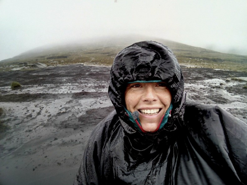
After the maelstrom of the previous night I awoke, although that does suggest I was sleeping!?, into a very soggy half light of morning. The rain was solidly falling in sheets, cloud was down around me and there was considerable wet ‘seepage’ into the tent – hardly surprising when every spot you stood saw your feet sinking a few centimetres into the sodden, wet ground. It was not exactly the scene of an idyllic Instagram‘able wild camping trip! (As I really didn’t get many meaningful pictures of these two days some of the following photos are from the previous day which did allow me to briefly see the beauty of these mountains!)

Brighter times the previous day!
I packed up quickly in the rain, impressed again at how the tent had seemed to take the conditions in it’s stride though not sure the same could be said for me. My goal for now was to get to the road, climb the mountain on the other side of the valley and reach the shelter above Glendalough valley. With visibility poor I used the line of a fence to make some progress upward. It was hard going as there was no path and the terrain was steep with thick, deep heather and rocks and everything was wet and slippery. All too soon I had to navigate across the open hillside to get back onto the ridge for the climb to Tonelagee, the provinces third highest summit. Emerging from the sheltered side of the ridge all hell seemed to break loose approaching the summit plateau. Gale forces winds pummelled me and I had difficulty staying on my feet. The wind whipped the rain sharply, lashing it painfully against my face. Tonelagee or Tóin le Gaoith literally translates as ‘backside to the wind’ and as soon as I had reached the summit trig pillar I took the name as sensible advice, turned away from the onslaught and hurriedly found my route off the top.
I had been looking forward to stunning views of the heart shaped lake of Lough Ouler below but there was only thick, misty cloud swirling in the void below, a smoking basin below a precipitous drop. I had been so focused on reaching the small road at the foot of the valley and distracted by the intensity of the weather I had almost forgotten about the small matter of a river crossing between me, the road and my onward route. The map showed a definite crossing place and suggested another (albeit without a bridge of any kind) but it had been raining heavily for over eighteen hours by the time I reached it and the Glenmacnass river was now in spate, churning wild white-water over the rocks between fast moving deep channels that appeared to be easily chest height in places. I would not be crossing so easily!

Stopped in my tracks!
It was slightly surreal to come off the mountain and see the road and small parking area right there, barely ten metres from where I stood but with no way to reach it. To the left stood a forest and the map showed some buildings and potentially a bridge over the river about 2km downstream. The forest was not too dense and although quite flooded in places I could make relatively easy progress through it. However, I very soon came to an abrupt halt at the huge Glenmacnass Waterfall head as it raged over a rocky precipice and vanished, out of sight, to the valley far below. I had completely underestimated the tight band of contour lines on the map which were realised here as a long, steep drop to the flat land of the valley and my potential escape route. Peering over the edge there was a short section of smooth rock I could have climbed down but with no way of knowing exactly what was beyond and considering I would have some major difficulty getting back up this rock, particularly with my heavy pack I reluctantly wrote off this route and turned to pick my way back through the trees.
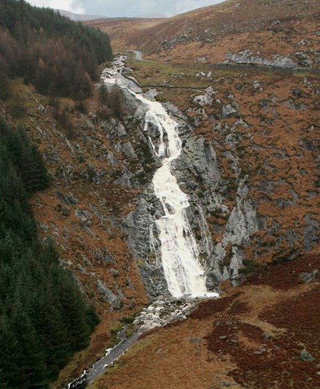
The Glenmacnass Waterfall – even on a calm day like this I doubt I would be attempting the climb down!
My next plan was to follow the river upstream where I hoped it would eventually be crossable. This was a hard slog and there were many tributaries that had sprung up, all pouring into the river from the mountainside and they all had to be crossed, often involving lengthy clambers inward to higher ground to find safe places to get over. Eventually I reached the section where the river split into two and was able to cross one part but the main torrent didn’t seem to let up at all. I caught a glimpse of another huge waterfall coming over the edge of a sheer corrie wall which was clearly feeding into the river. It was obvious there would be no way to safely get over this river and any onward route would involve a very steep climb up the corrie sides to get to the top of that waterfall. This was not really a feasible option, it was too late in the day to end up back on top of a mountain in the conditions and the climb could be fairly treacherous as it had been raining heavily non-stop the whole day. I made the decision to retrace my steps immediately in order to get past the tributaries before they got worse and potentially impassable which would have left me cut off and stranded. After five hours battling along this river I made camp for the night on slightly higher ground to rest and think about the other escape options. Again I managed to find some shelter from the worst of the wind, although all the ground was well waterlogged so pitched over a patch of heather to try to stay above the water. One advantage of no one being around meant I could freely strip off all my dripping wet clothes and leave them outside before diving into the tent to warm up. My impromptu pitch was quite sloping and I had to literally hook myself over a thick, gnarly heather stalk that was sticking up to avoid constantly sliding off the air mat but I was warm and relatively dry inside so long as I kept away from the water pooling in the corners of the tent so hunkered down for another wild night on the side of the mountain.

Looking and feeling pretty frazzled after unsuccessful hours trying to cross the river!
*This day brought home to me the importance of having the right gear and level of experience for your chosen outdoors activities. I was certainly pushed outside my comfort zone but at no time felt scared or overly concerned, a good part due to the fact I was carrying food for a week, shelter and a set of dry thermals wrapped in 4 layers of dry bags. There were several ‘escape’ routes so it was certain one would pan out and even if not I could have hung out for several days if need be until conditions improved, it would have been uncomfortable and pretty miserable but I would have been fine and at least would have no problems finding water!
Day 4 – Escape from Tonelagee Mountain…
Perhaps unsurprisingly it was raining still as daylight broke. I was surrounded by sheep who, quite frankly, were all looking a bit miffed with me for spending the night on their favourite patch, the only tiny square of non-flooded ground to be had as far as the eye could see. It was the first time I have noticed that very wet sheep shake themselves dry in exactly the same way as dogs do!? Fortunately they hadn’t chewed through my tent in retaliation and despite the little pools of water in the corners it had held up excellently once again. A bit of cold food and an uncomfortable nights rest constantly shimmying back up the tent after continually becoming unhooked from the pokey heather stalk I had ‘hooked’ my hip over had given me plenty of time for problem solving and I had devised a plan! The only other potential escape route on this side of the mountain was short and would get me back on track but with it’s own potentially problematic water crossing and a couple of areas of ‘unknown’ I decided not to even bother. The most sensible option was clearly to climb back over the mountain and get off the other side. I had avoided this option as, (a) I felt a bit lazy about climbing back up and over the three summits I had already climbed the day before and (b) I didn’t fancy revisiting the insane wind conditions up there – I guess the second excuse was a valid argument! From the summit of Tonelagee there were three options – a very direct route straight down off the mountain to the road – my clever use of maths in relation to contours and height lost over distance gave me the calculated result of “it’s a bit steep” and I dismissed this as steep was more tricky with the heavy pack and would undoubtedly be very slippery and possible a near vertical mud slick by now, not to mention it would be straight into the gale force wind. The second option was to follow the south east ridge for five miles towards Glendalough. This was my initial choice but not knowing what surprises that five mile ridge might contain and given that it would be fully exposed and the cloud was down with very limited visibility I wimped out and went for the third option which was to retrace the way I had come yesterday and use the forestry track ‘escape route’ I had identified on my previous camp. This was further and meant some seven miles of hoofing it along the road to get back on track but I knew the route, there were no hidden surprises and no watercourses potentially out of control. There was a vague possibility that a bridge before the road could have been damaged or washed away but I figured some things were just beyond my control.

Plan made, I wrung out as much water as I could from my sopping clothes and put them back on (that was a particular joy!) It was still not going to be an easy day. I had a long steep climb back up and the wind was just as violent as the day before but at least once I got over Tonelagee plateau it would be behind me. There was a short, sketchy section to navigate over rough ground in very bad visibility to get to the forest and avoid dropping too far back into Barnacullian Bog but fortunately it only had a few small peat hags to negotiate. It was no small relief then when I finally hit the forestry track and started to believe I may actually get off this mountain today. Crossing the fully intact bridge and suddenly being spat out onto the road into a world of people whizzing by in their warm, dry cars was a bit surreal after literally seeing nobody for three days in the hills. I imagined in good weather there would have been far more hill-goers enjoying these mountains especially as it was technically summertime but they were probably all far too sensible to be wading about in these conditions.
On the long slog along the road I had time to think about what to do next, something I had put off, simply focusing on getting off the mountain before anything else. I really wanted to find somewhere to regroup, dry out all my wet gear and think about how get my ‘Wicklow Round’ back on course. It was bad timing that it was Saturday and I knew the very popular Glendalough Hostel was fully booked all weekend but I decided to give it a try and perhaps appeal to their sympathies to at least allow me to hang my stuff in their drying room for a few hours.Just a mile from the hostel a couple of ladies in a car stopped and insisted on giving me a lift down to the hostel. They had abandoned their own planned Saturday afternoon group walk along the St. Kevin’s Road due to a river stepping stone crossing being washed out and since it was still raining had decided to go to the pub instead.
Standing, dripping in my own slowly growing pool of water at the Glendalough Hostel reception they did indeed go above and beyond to help me out. Not only was I welcome to use the drying room and even take a wash for no charge they also promised to find me a bed somewhere. Personally, I was quite happy to put my sleeping mat down in the corner by the vending machine but this was a welcome opportunity to dry everything out, repack and study the maps to get this mountain challenge back on track and all accompanied with a luxurious supply of hot coffee!

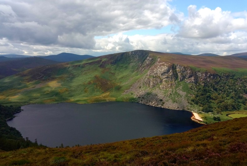
I already missed the beautiful scenes from the first day I entered the Wicklows!
Despite everything that had happened over the last couple of days, with my kit on it’s way to being dried out and some warm food and drink inside me, it really wasn’t too long before I was itching to get back out there!

Great reading on a similar weather day in South Wales today! When do you your write ups? After long days like this, I never get the self promised collation of photos and writing done..whats your secret, Tina?!
LikeLike
Hi Paul, I know exactly what you mean! I am always behind with this. I try to be disciplined to write up my stats, record summits, make a diary note of the day and download pics when I get back to the camper each time, not to mention route planning, sticking together maps and refilling my kit for the next day. However, editing pics , making posts and writing ANYTHING does get put off often. Hence the glaring lack of regular blogs. Then again, (Un)luckily there no shortage of rough weather days to just take a break and try to get caught up…..or… I try to do it at work🤣. But, yes, usually I just want to go to sleep if it’s been a big day on the hill. All the best to you, sorry I don’t have any great solutions.
LikeLike
Thanks! I just fall asleep after a glass of red or a pint after such a long day and the write up doesn’t happen. I say I will do it in the morning but I like to get out! Bad weather days are the only solution…which is why the weather in the British Isles is just right I suppose! All the best for your continuing adventures…
LikeLike
Thanks Paul, you too👍
LikeLike